Юмагузинская ГЭС. Юмагузинская гэсЮмагузинская гидроэлектростанцияВода является не только источником жизни, но иногда и источником катастроф, которые происходят в результате наводнений. С давних времен люди пытались научиться управлять водой и получать максимальный эффект от ее использования. Для таких целей человечество изобрело гидроэлектростанции. Первые ГЭС в России начали вводиться в эксплуатацию с 1892 года.
Постепенно изучая и совершенствуя процесс выработки электроэнергии с использованием воды, ГЭС стали появляться на многих реках нашей бескрайней Родины. Одна из таких ГЭС находится в Кугарчинском районе Республики Башкортостан. Юмагузинская гидроэлектростанция расположена на реке Белой рядом с одноименным поселком Юмагузино. Строить ГЭС на реке Белой планировалось еще во времена существования Советского Союза. В 1970-хх годах активно решались вопросы по водоснабжению промышленных районов Башкирской АССР. В 1982 году были начаты работы, результатом которых должно было стать образование нового Иштугановского водохранилища, расположенного на 14 км ниже нынешней Юмагузинской ГЭС. Однако подготовительные работы встретили активный протест со стороны экологов, которые пользовались в те времена поддержкой среди населения. В результате в 1989 году все работы были приостановлены. Позднее вместо Иштугановского водохранилища разработали проект, который представлял собой каскад из трех водохранилищ, расположенных на реке Белая. В результате создания такого каскада значительно уменьшалась затапливаемая территория.
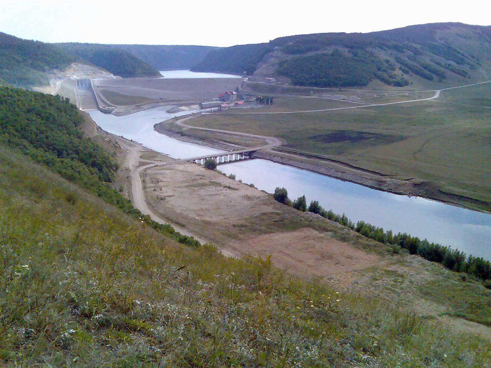
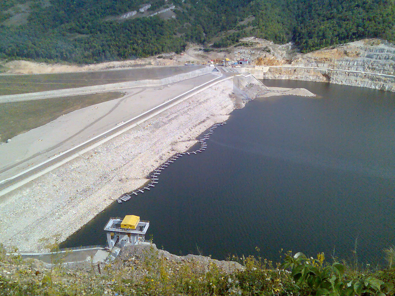
Одним из первых водохранилищ в 1998 году принялись к строительству Юмагузинского. Строительство не затягивалось и 21 июля 2007 года гидроузел уже ввели в эксплуатацию. Первое заполнение вновь образованного Юмагузинского водохранилища было весной 2004 года. На сегодняшний день водохранилище занимает площадь в 35,6 кв. км с полным объемом 890 млн кубических метров. Основной задачей создания этого гидроузла является решение проблем с затоплением близлижайших территорий во время паводков, а также обеспечение водоснабжения и выработка электроэнергии. Юмагузинская ГЭС входит в состав Кумертауской ТЭЦ. Электрическая мощность ГЭС составляет 45 МВт. В самом здании Юмагузинской ГЭС установлено три поворотно-лопастных гидроагрегата, каждый по мощности в 15 МВт.
В апреле 2016 года благодаря активной эксплуатации ГЭС удалось предотвратить подтопление в результате резкого увеличения уровня воды в реке Белая.
Автор фотографий: Konstantin Tsibin greenexp.ru Юмагузинская ГЭС ВикипедияЮмагузинская гидроэлектростанция — ГЭС на реке Белой в Кугарчинском районе Башкортостана. Общие сведенияСтроительство ГЭС началось в 1998 году, окончилось в 2007 году. Состав сооружений ГЭС: Мощность ГЭС — 45 МВт. В здании ГЭС установлено три поворотно-лопастных гидроагрегата мощностью по 15 МВт, работающих при расчётном напоре 40 м. Напорные сооружения ГЭС образуют Юмагузинское водохранилище площадью 35,6 км², полным объёмом 890 млн.м³. ГЭС спроектирована институтом «Гидропроект». Юмагузинский гидроузел решает в первую очередь задачи обеспечения водоснабжения и защиты от наводнений, с попутной выработкой электроэнергии. Юмагузинская ГЭС входит в состав ООО «Башкирская генерирующая компания», строительство осуществлялось ООО «Юмагузинское водохранилище». Экологические проблемыЮмагузинский гидроузел создан в узкой горной долине, и площади затоплений ценных земель невелики. Гидроузел критикуется за затопление земель национального парка «Башкирия», сокращение ареалов ряда редких животных и растений. Высказывались опасения по поводу ухудшения качества воды в водохранилище и реке Белой, а также потери воды из водохранилища в подземные карстовые пустоты. История строительстваПлотина Юмагузинской ГЭССоздание водохранилища для решения проблем водоснабжения промышленных районов Башкирской АССР проектировалось с 1970-х гг. В 1982 были начаты подготовительные работы по созданию Иштугановского водохранилища на р. Белой, в 14 км ниже створа Юмагузинской ГЭС (объёмом 3 км³ и площадью более 150 км2). Строительство водохранилища встретило активные протесты экологов, пользовавшихся в конце 1980-х гг. большой общественной поддержкой, и было остановлено в 1989 году. В последующем вместо Иштугановского водохранилища был разработан проект каскада из трёх водохранилищ на реке Белой с меньшими площадями затопления. В 1998 году началось строительство первого из них — Юмагузинского. Строительство гидроузла шло быстрыми темпами. 10 июня 2003 г. было перекрыто русло реки Белой, 7 октября 2004 г. пущен первый гидроагрегат, в декабре 2004 г. — второй, 2 апреля 2005 г. — третий. 21 июля 2007 года гидроузел был торжественно введён в эксплуатацию. ПримечанияСсылкиwikiredia.ru Юмагузинская ГЭС - это... Что такое Юмагузинская ГЭС?
Координаты: 52°57′23″ с. ш. 56°24′53″ в. д. / 52.956389° с. ш. 56.414722° в. д. (G) (O) (Я)52.956389, 56.414722 Юмагузинская гидроэлектростанция — ГЭС на реке Белой в Башкирии. Общие сведенияСтроительство ГЭС началось в 1998 году, окончилось в 2007 году. Состав сооружений ГЭС:
Мощность ГЭС — 45 МВт. В здании ГЭС установлено три поворотно-лопастных гидроагрегата мощностью по 15 МВт, работающих при расчётном напоре 40 м. Напорные сооружения ГЭС образуют Юмагузинское водохранилище площадью 35,6 км², полным объёмом 890 млн.м³. ГЭС спроектирована институтом «Гидропроект». Юмагузинский гидроузел решает в первую очередь задачи обеспечения водоснабжения и защиты от наводнений, с попутной выработкой электроэнергии. Юмагузинская ГЭС входит в состав ОАО «Башкирэнерго», строительство осуществлялось ООО «Юмагузинское водохранилище». Экологические проблемыЮмагузинский гидроузел создан в узкой горной долине, и площади затоплений ценных земель невелики. Гидроузел критикуется за затопление земель национального парка «Башкирия», сокращение ареалов ряда редких животных и растений. Высказывались опасения по поводу ухудшения качества воды в водохранилище и реке Белая, а также потери воды из водохранилища в подземные карстовые пустоты. История строительстваПлотина Юмагузинской ГЭССоздание водохранилища для решения проблем водоснабжения промышленных районов Башкирии проектировалось с 1970-х гг. В 1982 были начаты подготовительные работы по созданию Иштугановского водохранилища на р. Белой, в 14 км ниже створа Юмагузинской ГЭС (объёмом 3 км³ и площадью более 150 кв.км). Строительство водохранилища встретило активные протесты экологов, пользовавшихся в конце 1980-х гг. большой общественной поддержкой, и было остановлено в 1989. В последующем, вместо Иштугановского водохранилища был разработан проект каскада из трёх водохранилищ на реке Белой с меньшими площадями затопления. В 1998 началось строительство первого из них — Юмагузинского. Строительство гидроузла шло быстрыми темпами. 10 июня 2003 было перекрыто русло реки Белой, 7 октября 2004 пущен первый гидроагрегат, в декабре 2004 — второй, 2 апреля 2005 — третий. 21 июля 2007 года гидроузел торжественно введен в эксплуатацию. Ссылкиdic.academic.ru Юмагузинская ГЭС — ВикипедияМатериал из Википедии — свободной энциклопедии
Юмагузинская гидроэлектростанция — ГЭС на реке Белой в Кугарчинском районе Башкортостана. Общие сведенияСтроительство ГЭС началось в 1998 году, окончилось в 2007 году. Состав сооружений ГЭС: Мощность ГЭС — 45 МВт. В здании ГЭС установлено три поворотно-лопастных гидроагрегата мощностью по 15 МВт, работающих при расчётном напоре 40 м. Напорные сооружения ГЭС образуют Юмагузинское водохранилище площадью 35,6 км², полным объёмом 890 млн.м³. ГЭС спроектирована институтом «Гидропроект». Юмагузинский гидроузел решает в первую очередь задачи обеспечения водоснабжения и защиты от наводнений, с попутной выработкой электроэнергии. Юмагузинская ГЭС входит в состав ООО «Башкирская генерирующая компания», строительство осуществлялось ООО «Юмагузинское водохранилище». Видео по темеЭкологические проблемыЮмагузинский гидроузел создан в узкой горной долине, и площади затоплений ценных земель невелики. Гидроузел критикуется за затопление земель национального парка «Башкирия», сокращение ареалов ряда редких животных и растений. Высказывались опасения по поводу ухудшения качества воды в водохранилище и реке Белая, а также потери воды из водохранилища в подземные карстовые пустоты. История строительства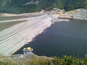 Плотина Юмагузинской ГЭС Плотина Юмагузинской ГЭС Создание водохранилища для решения проблем водоснабжения промышленных районов Башкирской АССР проектировалось с 1970-х гг. В 1982 были начаты подготовительные работы по созданию Иштугановского водохранилища на р. Белой, в 14 км ниже створа Юмагузинской ГЭС (объёмом 3 км³ и площадью более 150 км2). Строительство водохранилища встретило активные протесты экологов, пользовавшихся в конце 1980-х гг. большой общественной поддержкой, и было остановлено в 1989 году. В последующем, вместо Иштугановского водохранилища был разработан проект каскада из трёх водохранилищ на реке Белой с меньшими площадями затопления. В 1998 году началось строительство первого из них — Юмагузинского. Строительство гидроузла шло быстрыми темпами. 10 июня 2003 г. было перекрыто русло реки Белой, 7 октября 2004 г. пущен первый гидроагрегат, в декабре 2004 г. — второй, 2 апреля 2005 г. — третий. 21 июля 2007 года гидроузел был торжественно введён в эксплуатацию. ПримечанияСсылкиwikipedia.green Юмагузинская ГЭС — Википедия (с комментариями)Материал из Википедии — свободной энциклопедии
Юмагузинская гидроэлектростанция — ГЭС на реке Белой в Кугарчинском районе Башкортостана. Общие сведенияСтроительство ГЭС началось в 1998 году, окончилось в 2007 году. Состав сооружений ГЭС: Мощность ГЭС — 45 МВт. В здании ГЭС установлено три поворотно-лопастных гидроагрегата мощностью по 15 МВт, работающих при расчётном напоре 40 м. Напорные сооружения ГЭС образуют Юмагузинское водохранилище площадью 35,6 км², полным объёмом 890 млн.м³. ГЭС спроектирована институтом «Гидропроект». Юмагузинский гидроузел решает в первую очередь задачи обеспечения водоснабжения и защиты от наводнений, с попутной выработкой электроэнергии. Юмагузинская ГЭС входит в состав ООО «Башкирская генерирующая компания», строительство осуществлялось ООО «Юмагузинское водохранилище». Экологические проблемыЮмагузинский гидроузел создан в узкой горной долине, и площади затоплений ценных земель невелики. Гидроузел критикуется за затопление земель национального парка «Башкирия», сокращение ареалов ряда редких животных и растений. Высказывались опасения по поводу ухудшения качества воды в водохранилище и реке Белая, а также потери воды из водохранилища в подземные карстовые пустоты. История строительства
В последующем, вместо Иштугановского водохранилища был разработан проект каскада из трёх водохранилищ на реке Белой с меньшими площадями затопления. В 1998 году началось строительство первого из них — Юмагузинского. Строительство гидроузла шло быстрыми темпами. 10 июня 2003 г. было перекрыто русло реки Белой, 7 октября 2004 г. пущен первый гидроагрегат, в декабре 2004 г. — второй, 2 апреля 2005 г. — третий. 21 июля 2007 года гидроузел был торжественно введён в эксплуатацию. Напишите отзыв о статье "Юмагузинская ГЭС"ПримечанияСсылки
Отрывок, характеризующий Юмагузинская ГЭС«Завтра, очень может быть, пошлют с каким нибудь приказанием к государю, – подумал он. – Слава Богу».Крики и огни в неприятельской армии происходили оттого, что в то время, как по войскам читали приказ Наполеона, сам император верхом объезжал свои бивуаки. Солдаты, увидав императора, зажигали пуки соломы и с криками: vive l'empereur! бежали за ним. Приказ Наполеона был следующий: «Солдаты! Русская армия выходит против вас, чтобы отмстить за австрийскую, ульмскую армию. Это те же баталионы, которые вы разбили при Голлабрунне и которые вы с тех пор преследовали постоянно до этого места. Позиции, которые мы занимаем, – могущественны, и пока они будут итти, чтоб обойти меня справа, они выставят мне фланг! Солдаты! Я сам буду руководить вашими баталионами. Я буду держаться далеко от огня, если вы, с вашей обычной храбростью, внесете в ряды неприятельские беспорядок и смятение; но если победа будет хоть одну минуту сомнительна, вы увидите вашего императора, подвергающегося первым ударам неприятеля, потому что не может быть колебания в победе, особенно в тот день, в который идет речь о чести французской пехоты, которая так необходима для чести своей нации. Под предлогом увода раненых не расстроивать ряда! Каждый да будет вполне проникнут мыслию, что надо победить этих наемников Англии, воодушевленных такою ненавистью против нашей нации. Эта победа окончит наш поход, и мы можем возвратиться на зимние квартиры, где застанут нас новые французские войска, которые формируются во Франции; и тогда мир, который я заключу, будет достоин моего народа, вас и меня. Наполеон». В 5 часов утра еще было совсем темно. Войска центра, резервов и правый фланг Багратиона стояли еще неподвижно; но на левом фланге колонны пехоты, кавалерии и артиллерии, долженствовавшие первые спуститься с высот, для того чтобы атаковать французский правый фланг и отбросить его, по диспозиции, в Богемские горы, уже зашевелились и начали подниматься с своих ночлегов. Дым от костров, в которые бросали всё лишнее, ел глаза. Было холодно и темно. Офицеры торопливо пили чай и завтракали, солдаты пережевывали сухари, отбивали ногами дробь, согреваясь, и стекались против огней, бросая в дрова остатки балаганов, стулья, столы, колеса, кадушки, всё лишнее, что нельзя было увезти с собою. Австрийские колонновожатые сновали между русскими войсками и служили предвестниками выступления. Как только показывался австрийский офицер около стоянки полкового командира, полк начинал шевелиться: солдаты сбегались от костров, прятали в голенища трубочки, мешочки в повозки, разбирали ружья и строились. Офицеры застегивались, надевали шпаги и ранцы и, покрикивая, обходили ряды; обозные и денщики запрягали, укладывали и увязывали повозки. Адъютанты, батальонные и полковые командиры садились верхами, крестились, отдавали последние приказания, наставления и поручения остающимся обозным, и звучал однообразный топот тысячей ног. Колонны двигались, не зная куда и не видя от окружавших людей, от дыма и от усиливающегося тумана ни той местности, из которой они выходили, ни той, в которую они вступали. Солдат в движении так же окружен, ограничен и влеком своим полком, как моряк кораблем, на котором он находится. Как бы далеко он ни прошел, в какие бы странные, неведомые и опасные широты ни вступил он, вокруг него – как для моряка всегда и везде те же палубы, мачты, канаты своего корабля – всегда и везде те же товарищи, те же ряды, тот же фельдфебель Иван Митрич, та же ротная собака Жучка, то же начальство. Солдат редко желает знать те широты, в которых находится весь корабль его; но в день сражения, Бог знает как и откуда, в нравственном мире войска слышится одна для всех строгая нота, которая звучит приближением чего то решительного и торжественного и вызывает их на несвойственное им любопытство. Солдаты в дни сражений возбужденно стараются выйти из интересов своего полка, прислушиваются, приглядываются и жадно расспрашивают о том, что делается вокруг них. wiki-org.ru Юмагузинская ГЭСЮмагузинская гидроэлектростанция — строящаяся ГЭС на реке Белой в Башкирии. Общие сведенияСтроительство ГЭС началось в 1998, окончание строительства планируется в 2006. Состав сооружений ГЭС:
Мощность ГЭС — 45 МВт. В здании ГЭС установлено 3 поворотно-лопастных гидроагрегата мощностью по 15 МВт, работающих при расчётном напоре 40 м. Напорные сооружения ГЭС образуют Юмагузинское водохранилище площадью 35,6 км. ГЭС спроектирована институтом «Гидропроект» Юмагузинский гидроузел решает в первую очередь задачи обеспечения водоснабжения и защиты от наводнений, с попутной выработкой электроэнергии. Юмагузинская ГЭС входит в состав ОАО «Башкирэнерго», строительство осуществляется ООО «Юмагузинское водохранилище». Экологические проблемыЮмагузинский гидроузел создаётся в узкой горной долине, и площади затоплений ценных земель невелики. Гидроузел критикуется за затопление земель национального парка «Башкирия», сокращение ареалов ряда редких животных и растений. Высказываются опасения ухудшения качества воды в водохранилище и реке Белая, а также потери воды из водохранилища в подземные карстовые пустоты. История строительстваСоздание водохранилища для решения проблем водоснабжения промышленных районов Башкирии проектировалось с 1970-х гг. В 1982 были начаты подготовительные работы по созданию Иштугановского водохранилища на р.Белая, в 14 км ниже створа Юмагузинской ГЭС (объёмом 3 куб.км и площадью более 150 кв.км). Строительство водохранилища встретило активные протесты экологов, пользовавшихся в конце 1980-х гг. большой общественной поддержкой, и было остановлено в 1989. В последующем вместо Иштугановского водохранилища был разработан проект каскада из 3 водохранилищ на реке Белая с меньшими площадями затопления. В 1998 началось строительство первого из них — Юмагузинского. Строительство гидроузла шло быстрыми темпами. 10 июня 2003 было перекрыто русло р.Белая, 7 октября 2004 пущен первый гидроагрегат, в декабре 2004 — второй, 2 апреля 2005 — третий. Сдача ГЭС Госкомиссии намечена на конец 2006. Ссылкиmediaknowledge.ru Юмагузинская ГЭС - WikiVisually1. Россия – Russia, also officially the Russian Federation, is a country in Eurasia. The European western part of the country is more populated and urbanised than the eastern. Russias capital Moscow is one of the largest cities in the world, other urban centers include Saint Petersburg, Novosibirsk, Yekaterinburg, Nizhny Novgorod. Extending across the entirety of Northern Asia and much of Eastern Europe, Russia spans eleven time zones and incorporates a range of environments. It shares maritime borders with Japan by the Sea of Okhotsk, the East Slavs emerged as a recognizable group in Europe between the 3rd and 8th centuries AD. Founded and ruled by a Varangian warrior elite and their descendants, in 988 it adopted Orthodox Christianity from the Byzantine Empire, beginning the synthesis of Byzantine and Slavic cultures that defined Russian culture for the next millennium. Rus ultimately disintegrated into a number of states, most of the Rus lands were overrun by the Mongol invasion. The Soviet Union played a role in the Allied victory in World War II. The Soviet era saw some of the most significant technological achievements of the 20th century, including the worlds first human-made satellite and the launching of the first humans in space. By the end of 1990, the Soviet Union had the second largest economy, largest standing military in the world. It is governed as a federal semi-presidential republic, the Russian economy ranks as the twelfth largest by nominal GDP and sixth largest by purchasing power parity in 2015. Russias extensive mineral and energy resources are the largest such reserves in the world, making it one of the producers of oil. The country is one of the five recognized nuclear weapons states and possesses the largest stockpile of weapons of mass destruction, Russia is a great power as well as a regional power and has been characterised as a potential superpower. The name Russia is derived from Rus, a state populated mostly by the East Slavs. However, this name became more prominent in the later history, and the country typically was called by its inhabitants Русская Земля. In order to distinguish this state from other states derived from it, it is denoted as Kievan Rus by modern historiography, an old Latin version of the name Rus was Ruthenia, mostly applied to the western and southern regions of Rus that were adjacent to Catholic Europe. The current name of the country, Россия, comes from the Byzantine Greek designation of the Kievan Rus, the standard way to refer to citizens of Russia is Russians in English and rossiyane in Russian. There are two Russian words which are translated into English as Russians 2. Река – A river is a natural flowing watercourse, usually freshwater, flowing towards an ocean, sea, lake or another river. In some cases a river flows into the ground and becomes dry at the end of its course without reaching another body of water, small rivers can be referred to using names such as stream, creek, brook, rivulet, and rill. There are no official definitions for the term river as applied to geographic features. Many names for small rivers are specific to geographic location, examples are run in parts of the United States, burn in Scotland and northeast England. Sometimes a river is defined as being larger than a creek, but not always, Rivers are part of the hydrological cycle. Potamology is the study of rivers while limnology is the study of inland waters in general. Extraterrestrial rivers of liquid hydrocarbons have recently found on Titan. Channels may indicate past rivers on other planets, specifically outflow channels on Mars and rivers are theorised to exist on planets, a river begins at a source, follows a path called a course, and ends at a mouth or mouths. The water in a river is confined to a channel. In larger rivers there is also a wider floodplain shaped by flood-waters over-topping the channel. Floodplains may be wide in relation to the size of the river channel. This distinction between river channel and floodplain can be blurred, especially in areas where the floodplain of a river channel can become greatly developed by housing. Rivers can flow down mountains, through valleys or along plains, the term upriver refers to the direction towards the source of the river, i. e. against the direction of flow. Likewise, the term describes the direction towards the mouth of the river. The term left bank refers to the bank in the direction of flow. The river channel typically contains a stream of water, but some rivers flow as several interconnecting streams of water. Extensive braided rivers are now found in only a few regions worldwide and they also occur on peneplains and some of the larger river deltas. Anastamosing rivers are similar to braided rivers and are quite rare 3. Белая (приток Камы) – Belaya River is a river in Bashkortostan, Russian Federation. Its source lies in the south-western Ural Mountains, settlements along the Belaya include Beloretsk, Sterlitamak, Ufa, and Birsk. The Belaya flows into the Kama River near Neftekamsk 4. Киловатт-час – The kilowatt-hour is a derived unit of energy equal to 3.6 megajoules. If the energy is being transmitted or used at a constant rate over a period of time, the kilowatt-hour is commonly used as a billing unit for energy delivered to consumers by electric utilities. The kilowatt-hour is a unit of energy equivalent to one kilowatt of power sustained for one hour. 1 k W ⋅ h = =3600 =3600 k J =3.6 M J One watt is equal to 1 J/s. One kilowatt-hour is 3.6 megajoules, which is the amount of energy converted if work is done at a rate of one thousand watts for one hour. The base unit of energy within the International System of Units is the joule, the hour is a unit of time outside the SI, making the kilowatt-hour a non-SI unit of energy. The kilowatt-hour is not listed among the non-SI units accepted by the BIPM for use with the SI, although the hour, an electric heater rated at 1000 watts, operating for one hour uses one kilowatt-hour of energy. A television rated at 100 watts operating for 10 hours continuously uses one kilowatt-hour, a 40-watt light bulb operating continuously for 25 hours uses one kilowatt-hour. Electrical energy is sold in kilowatt-hours, cost of running equipment is the product of power in kilowatts multiplied by running time in hours, the unit price of electricity may depend upon the rate of consumption and the time of day. Industrial users may also have extra charges according to their peak usage, the symbol kWh is commonly used in commercial, educational, scientific and media publications, and is the usual practice in electrical power engineering. Other abbreviations and symbols may be encountered, kW h is less commonly used and it is consistent with SI standards. This is supported by a standard issued jointly by an international and national organization. However, at least one major usage guide and the IEEE/ASTM standard allow kWh, One guide published by NIST specifically recommends avoiding kWh to avoid possible confusion. KW·h is, like kW h, preferred with SI standards, the US official fuel-economy window sticker for electric vehicles uses the abbreviation kW-hrs. Variations in capitalization are sometimes seen, KWh, KWH, kwh, the notation kW/h, as a symbol for kilowatt-hour, is not correct. To convert a quantity measured in a unit in the column to the units in the top row, multiply by the factor in the cell where the row. All the SI prefixes are commonly applied to the watt-hour, a kilowatt-hour is 1,000 W·h (symbols kW·h, kWh or kW h, a megawatt-hour is 1 million W·h, a milliwatt-hour is 1/1000 W·h and so on. Megawatt-hours, gigawatt-hours, and terawatt-hours are often used for metering larger amounts of energy to industrial customers 5. Напор – Hydraulic head or piezometric head is a specific measurement of liquid pressure above a geodetic datum. It is usually measured as a surface elevation, expressed in units of length. In an aquifer, it can be calculated from the depth to water in a piezometric well, hydraulic head can similarly be measured in a column of water using a standpipe piezometer by measuring the height of the water surface in the tube relative to a common datum. The hydraulic head can be used to determine a hydraulic gradient between two or more points, in fluid dynamics, head is a concept that relates the energy in an incompressible fluid to the height of an equivalent static column of that fluid. Head is expressed in units of such as meters or feet. The static head of a pump is the height it can deliver. The capability of the pump at a certain RPM can be read from its Q-H curve, a common misconception is that the head equals the fluids energy per unit weight, while, in fact, the term with pressure does not represent any type of energy. Head is useful in specifying centrifugal pumps because their pumping characteristics tend to be independent of the fluids density, there are four types of head used to calculate the total head in and out of a pump, Velocity head is due to the bulk motion of a fluid. Its pressure head correspondent is the dynamic pressure, elevation head is due to the fluids weight, the gravitational force acting on a column of fluid. Pressure head is due to the pressure, the internal molecular motion of a fluid that exerts a force on its container. Resistance head is due to the forces acting against a fluids motion by the container. In a flowing fluid, it represents the energy of the due to its bulk motion. The total hydraulic head of a fluid is composed of pressure head, the pressure head is the equivalent gauge pressure of a column of water at the base of the piezometer, and the elevation head is the relative potential energy in terms of an elevation. The head equation, a form of the Bernoulli Principle for incompressible fluids, can be expressed as, h = ψ + z where h is the hydraulic head. This means that the hydraulic head calculation is dependent on the density of the water within the piezometer, for groundwater, it is also called the Darcy slope, since it determines the quantity of a Darcy flux or discharge. It also has applications in open-channel flow where it can be used to determine whether a reach is gaining or losing energy. This requires a hydraulic head field, which can only be obtained from a numerical model. As with any other example in physics, energy must flow from high to low and this vector can be used in conjunction with Darcys law and a tensor of hydraulic conductivity to determine the flux of water in three dimensions 6. Поворотно-лопастная турбина – The Kaplan turbine is a propeller-type water turbine which has adjustable blades. The Kaplan turbine was an evolution of the Francis turbine and its invention allowed efficient power production in low-head applications that was not possible with Francis turbines. The head ranges from 10–70 metres and the output from 5 to 200 MW, runner diameters are between 2 and 11 metres. Turbines rotate at a constant rate, which varies from facility to facility and that rate ranges from as low as 69.2 rpm to 429 rpm. Kaplan turbines are now used throughout world in high-flow, low-head power production. Viktor Kaplan living in Brno, Czech Republic, obtained his first patent for an adjustable blade propeller turbine in 1912, but the development of a commercially successful machine would take another decade. Kaplan struggled with problems, and in 1922 abandoned his research for health reasons. In 1919 Kaplan installed a demonstration unit at Poděbrady, Czechoslovakia, in 1922 Voith introduced an 1100 HP Kaplan turbine for use mainly on rivers. In 1924 an 8 MW unit went on line at Lilla Edet and this marked the commercial success and widespread acceptance of Kaplan turbines. The Kaplan turbine is an outward flow turbine, which means that the working fluid changes pressure as it moves through the turbine. Power is recovered from both the head and from the kinetic energy of the flowing water. The design combines features of radial and axial turbines, the inlet is a scroll-shaped tube that wraps around the turbines wicket gate. Water is directed tangentially through the gate and spirals on to a propeller shaped runner. The outlet is a specially shaped tube that helps decelerate the water and recover kinetic energy. The turbine does not need to be at the lowest point of water flow as long as the tube remains full of water. A higher turbine location, however, increases the suction that is imparted on the blades by the draft tube. The resulting pressure drop may lead to cavitation, variable geometry of the wicket gate and turbine blades allow efficient operation for a range of flow conditions. Kaplan turbine efficiencies are typically over 90%, but may be lower in very low head applications, current areas of research include CFD driven efficiency improvements and new designs that raise survival rates of fish passing through 7. Шлюз (гидротехническое сооружение) – A lock is a device used for raising and lowering boats, ships and other watercraft between stretches of water of different levels on river and canal waterways. Locks are used to make a more easily navigable, or to allow a canal to cross land that is not level. Later canals used more and larger locks to allow a direct route to be taken. Since 2016 the largest lock worldwide is the Kieldrecht Lock in the Port of Antwerp, a pound lock is a type of lock that is used almost exclusively nowadays on canals and rivers. A pound lock has a chamber with gates at both ends that control the level of water in the pound, in contrast, an earlier design with a single gate was known as a flash lock. Pound locks were first used in medieval China during the Song Dynasty, having been pioneered by the government official and engineer Qiao Weiyue in 984. The gates were hanging gates, when they were closed the water accumulated like a tide until the level was reached. The water level could differ by 4 feet or 5 feet at each lock, in medieval Europe a sort of pound lock was built in 1373 at Vreeswijk, Netherlands. This pound lock serviced many ships at once in a large basin, yet the first true pound lock was built in 1396 at Damme near Bruges, Belgium. A famous civil engineer of pound locks in Europe was the Italian Bertola da Novate, who constructed 18 of them on the Naviglio di Bereguardo between the years 1452 and 1458. When a stretch of river is navigable, a lock is sometimes required to bypass an obstruction such as a rapid, dam. In large scale river navigation improvements, weirs and locks are used together, a river improved by these means is often called a Waterway or River Navigation. Sometimes a river is made entirely non-tidal by constructing a sea lock directly into the estuary, in more advanced river navigations, more locks are required. Where a longer cut bypasses a stretch of river, the upstream end of the cut will often be protected by a flood lock. The longer the cut, the greater the difference in level between start and end of the cut, so that a very long cut will need additional locks along its length. At this point, the cut is, in effect, a canal, Early completely artificial canals, across fairly flat countryside, would get round a small hill or depression by simply detouring around it. However, locks continued to be built to supplement these solutions, all pound locks have three elements, A watertight chamber connecting the upper and lower canals, and large enough to enclose one or more boats. The position of the chamber is fixed, but its level can vary 8. Распределительное устройство – In an electric power system, switchgear is the combination of electrical disconnect switches, fuses or circuit breakers used to control, protect and isolate electrical equipment. Switchgears are used both to de-energize equipment to work to be done and to clear faults downstream. This type of equipment is directly linked to the reliability of the electricity supply, the earliest central power stations used simple open knife switches, mounted on insulating panels of marble or asbestos. Power levels and voltages rapidly escalated, making opening manually operated switches too dangerous for anything other than isolation of a de-energized circuit, oil-filled equipment allowed arc energy to be contained and safely controlled. By the early 20th century, a switchgear line-up would be a structure with electrically operated switching elements. Today, oil-filled equipment has largely replaced by air-blast, vacuum, or SF6 equipment, allowing large currents. High-voltage switchgear was invented at the end of the 19th century for operating motors, the technology has been improved over time and can now be used with voltages up to 1,100 kV. Typically, switchgear in substations are located on both the high- and low-voltage sides of large power transformers, for industrial applications, a transformer and switchgear line-up may be combined in one housing, called a unitized substation. Switchgear also provides isolation of circuits from power supplies, switchgear is also used to enhance system availability by allowing more than one source to feed a load. Switchgears are as old as electricity generation, the first models were very primitive, all components were simply fixed to a wall. Later they were mounted on wooden panels, for reasons of fire protection, the wood was replaced by slate or marble. This led to an improvement, because the switching and measuring devices could be attached to the front. Switchgear for lower voltages may be enclosed within a building. For higher voltages, switchgear is typically mounted outdoors and insulated by air, gas-insulated switchgear saves space compared with air-insulated equipment, although the equipment cost is higher. Oil insulated switchgear presents an oil spill hazard, switches may be manually operated or have motor drives to allow for remote control. A switchgear may be a simple open-air isolator switch or it may be insulated by some other substance, an effective although more costly form of switchgear is the gas-insulated switchgear, where the conductors and contacts are insulated by pressurized sulfur hexafluoride gas. Other common types are oil or vacuum insulated switchgear, the combination of equipment within the switchgear enclosure allows them to interrupt fault currents of thousands of amps. A circuit breaker is the component that interrupts fault currents 9. Кугарчинский район – Kugarchinsky District is an administrative and municipal district, one of the fifty-four in the Republic of Bashkortostan, Russia. The area of the district is 3,371 square kilometers and its administrative center is the rural locality of Mrakovo. As of the 2010 Census, the population of the district was 31,444. The district was established on August 20,1930, within the framework of administrative divisions, Kugarchinsky District is one of the fifty-four in the Republic of Bashkortostan. The district is divided into 20 selsoviets, comprising 113 rural localities, as a municipal division, the district is incorporated as Kugarchinsky Municipal District. Its twenty selsoviets are incorporated as twenty rural settlements within the municipal district, the selo of Mrakovo serves as the administrative center of both the administrative and municipal district. Murtaza Rakhimov, first President of the Republic of Bashkortostan №ВС-22/1524 декабря1993 г, Закона №57-з от4 марта2014 г. «О внесении изменений и дополнений в Конституцию Республики Башкортостан», Опубликован, Ведомости Верховного Совета и Правительства Республики Башкортостан, №4-22, ст.146,1994. Постановление №391 от29 декабря2006 г, «Об утверждении реестра административно-территориальных единиц и населённых пунктов Республики Башкортостан», в ред. Постановления №61 от26 февраля2013 г, «О внесении изменений в реестр административно-территориальных единиц и населённых пунктов Республики Башкортостан». Опубликован, Ведомости Государственного Собрания – Курултая, Президента и Правительства Республики Башкортостан, №5, Закон №162-з от17 декабря2004 г. «О границах, статусе и административных центрах муниципальных образований в Республике Башкортостан», Закона №572-з от17 июля2012 г. «О внесении изменения в статью2 Закона Республики Башкортостан О границах, Вступил в силу в соответствии со статьёй33. Опубликован, Республика Башкортостан, №52,22 марта2005 г 10. Башкортостан – The Republic of Bashkortostan, also known as Bashkiria is a federal subject of Russia. It is located between the Volga River and the Ural Mountains and its capital is the city of Ufa. With the population of 4,072,292 as of the 2010 Census, Bashkurdistan, the first ethnic autonomy in Russia, was established on November 281917. On March 20,1919, it was transformed into the Bashkir ASSR, in accordance with the Constitution of Bashkortostan and Russian Federation Constitution, Bashkortostan is a state, but has no sovereignty. On 11 October 1990 Bashkortostan adopted the Declaration of State Sovereignty,11 October is Republic Day in Bashkortostan. The name Bashkortostan derives from the name of the Bashkir ethnic group, while the root of the name is Turkic, the suffix -stan is Persian, common to many Eurasian country-names. They speak the Bashkir language, which belongs to the Kypchak branch of the Turkic languages, the first settlements in the territory of modern Bashkortostan date from the early Paleolithic period, but the Bronze Age spurred an upsurge in the population of this territory. When people of the Abashevo culture started settling here they possessed high skills in manufacturing bronze tools, weapons and they were the first to establish permanent settlements in the Southern Urals. Bashkortostan takes its name from its native people — the Bashkirs, the Russian name of the country — Bashkiriya — formed at the end of the 16th century. Originally it appeared in the forms Bashkir land, Bashkir’, Bashkirda, the ethnonym Bashkirs first became known in the 7th century. His contemporary Ibn-Ruste described the Bashkirs as an independent people, occupying territories on both sides of the Ural mountain ridge between Volga, Kama, Tobol and upstream of Yaik river. After the early-feudal Mongolian state had broken down in the 14th century, the tribes that lived there were headed by bi. After Kazan fell to Ivan the Terrible in 1554–1555, representatives of western and northwestern Bashkir tribes approached the Tsar with a request to voluntarily join Muscovy, starting from the second half of the 16th century, Bashkirias territory began taking shape as a part of the Russian state. Ufa Governorate, with a center in Ufa, was formed in 1865— another step towards territorial identification, after the Russian Revolution of 1917 are All-Bashkir Qoroltays on which a decision on the need to create a national federal republic within Russia. The congress was formed the government of Bashkurdistan, the Pre-parliament - Kese-Qoroltay and other bodies of power and administration, in March 1919, based on the agreements of the Russian Government with the Bashkir Government was formed Bashkir Autonomous Soviet Socialist Republic. During the Soviet period, Bashkiria was granted broad autonomous rights— the first among other Russian regions, the administrative structure of the Bashkir ASSR was based on principles similar to those of other autonomous republics of Russia. On October 11,1990 the Supreme Soviet of the Republic adopted the Declaration on state sovereignty of the Bashkir ASSR, on February 25,1992, the Bashkir ASSR was renamed the Republic of Bashkortostan. Bashkortostan contains part of the southern Urals and the adjacent plains, many rivers are part of the deepwater transportation system of European Russia, they provide access to ports of the Baltic and Black seas wikivisually.com | ||||||||||||||||||||||||||||||||||||||||||||||||||||||||||||||||||||||||||
|
||||||||||||||||||
|
|
||||||||||||||||||
|
 Россия
 Россия
 Создание водохранилища для решения проблем водоснабжения промышленных районов Башкирской АССР проектировалось с 1970-х гг. В 1982 были начаты подготовительные работы по созданию Иштугановского водохранилища на р. Белой, в 14 км ниже створа Юмагузинской ГЭС (объёмом 3 км³ и площадью более 150 км2). Строительство водохранилища встретило активные протесты экологов, пользовавшихся в конце 1980-х гг. большой общественной поддержкой, и было остановлено в 1989 году.